Monday, December 12, 2011

Lab 10: Alternative Fuels

Alternative fuels, known as non-conventional or advanced fuels, are any materials or substances that can be used as fuels, other than conventional fuels. Conventional fuels include: fossil fuels (petroleum, coal, propane, and  natural gas), as well as artificial radioisotope fuels that are made in nuclear reactors, and store their energy.

Some well-known alternative fuels include biodiesel, bioalcohol (methanol, ethanol, butanol), hydrogen, vegetable oil, and other biomass sources.

Biodiesel
Biodiesel is the name of a clean burning alternative fuel, produced from domestic, renewable resources. Biodiesel contains no petroleum, but it can be blended at any level with petroleum diesel to create a biodiesel blend. It can be used in compression-ignition (diesel) engines with little or no modifications. Biodiesel is simple to use, biodegradable, nontoxic, and essentially free of sulfur and aromatics.

Bioethanol
Bioethanol is a form of renewable energy that can be produced from agricultural feedstocks. It can be made from very common crops such as sugar cane, potato, and corn. There are concerns about its production and use as it relates to increased food prices due to the large amount of arable land required for crops.
Ethanol is a clear colorless liquid, biodegradable, and low in toxicity. The most common ethanol fuel blend is 10% ethanol and 90% petrol (E10). Vehicle engines require no modifications to run on E10 and vehicle warranties are unaffected also.

Saturday, November 26, 2011

Mitochondrial Eve


Mitochondrial Eve refers to the matrilineal MRCA (most recent common ancestor). She is the woman from whom all living humans today descend, on their mother's side, and through the mothers of those mothers and so on. This goes all the way back until all lines converge on one person. One hundred percent of mitochondrial DNA (mtDNA) comes from the mother. Mitochondrial DNA is separate from regular DNA. Your mitochondrial DNA is identical to your mother, grandmother. great-grandmother, and so on, tracing back to mitochondrial eve's.

Mitochondrial Eve is estimated to have lived around 200,000 years ago, most likely in East Africa. The same mtDNA is found in the 5 main populations of the world: Africa, Asia, Europe, Australia, and New Guinea.

African runway model Alek Wek
Asian film star Jet Li
European soccer star David Beckham
Australian singer Kylie Minogue
The famous Papuan people of Papua New Guinea

Lab 9: Dog Parks

 
Dog Park in Macon, GA
Dog parks are facilities set aside for dogs to exercise and play off-leash in a controlled environment under the supervision of their owners. Though parks may vary, a typical dog park offers a 4 to 6 ft fence; double-gated entry and exit points; adequate drainage; benches for humans; shade for hot days; close parking; water fountains (for humans and dogs); tools to pick up and dispose of animal waste; and regular maintenance and cleaning of the grounds.

Advantages
There are many advantages to taking your dog to a dog park.
(1) Dog Socialization Advantages
    - Dog parks provide an excellent source of dog-to-dog social interaction as well as dog-to-people     social interaction.
(2) People Socialization Advantages
    - Dog parks provide an excellent source of people-to-people social interaction. Dog-oriented people can meet and interaction, and from this doggy play dates can be arranged.
(3) Physical and Mental Stimulation Advantages
    - Dog parks provide an excellent source of off-leash exercise for active dogs. They allow dogs to get adequate physical and mental exercise, thereby lessening destructive and annoying behaviors in general which can benefit society as a whole.
(4) Educational Advantages
    - Dog parks provide a good opportunity for owners to learn about dogs through observation and provides the opportunity to learn from more experienced owners. It also allows for well-mannered-dog advocates to demonstrate how they turned their dog into a well-mannered dog.
(5) Community Advantages
    - Dog parks which are designed for dogs only lessen the chance of owners letting their dogs off-leash in on-leash parks.
    - No cars, skateboarders, bikes, etc. likely to be encountered
    - More likely to encounter people who enjoy dogs
    - Could provide a location for community dog activities

Disadvantages
(1) For People
    - Potential of danger from aggressive dogs
    - Potential of danger of physical injury from dog-related hazards
    - Potential of lawsuits arising from dog fights
    - Potential for parasites
(2) For Dogs
    - Potential of danger from aggressive dogs
    - Intact dogs may create problems
    - Potential for parasites and disease
    - Potential for lack of impulse control and over-excitement
    - Not appropriate for small and large dogs at the same time
    - Potential for injury
(3) For the Community
    - Some people will not understand the concept and will abuse the park by not picking up after their dog, leaving their dog unattended, or allowing their dog to indulge in inappropriate behavior
    - Some people will not be educated enough about their dogs to know if a dog park is appropriate for their dog
    - Potential for noise
    - Potential liability issues

Lab 8: Darwin's Dilemma


One of the most spectacular events in the history of life is the Cambrian explosion, which is also one the great mysteries of science. This was a moment of geological time when complex animals first appeared on earth fully formed, without evidence of any evolutionary ancestors. Charles Darwin viewed this as an inexplicable mystery. He envisioned the evolution of life through a multitude of small, undirected steps. Yet, the fossil record reveals no such pattern of gradual development. Instead, early in the Cambrian period compound eyes, articulated limbs, sophisticated sensory organs, and skeletons burst into existence seemingly out of nowhere.

Hallucigenia
The fossils of the Burgess Shale, more than half a billion years old, preserve an intriguing glimpse of early life on Earth. These fossils merit special interest for several reasons: they were buried in an underwater avalanche of fine mud that preserved exceptionally fine details of the structure of their soft parts. Only hard parts are preserved in most other Cambrian deposits, limiting information within the geologic record; they represent an early snapshot of the complexity of evolving life systems. The Burgess Shale fossils as a group have already developed into a variety of sizes and shapes from the much simpler, pre-Cambrian life forms; many of them appear to be early ancestors of higher forms - from algae to the chordates (a major group of animals that includes human primates). Other appear unrelated to any living forms and their later disappearance presents an intriguing mystery.

The Burgess Shale Site 510 Million Years Ago
From this picture it is easy to imagine how an avalanche of fine mud sliding down from the submerged reef top would have carried off any animals living in the shallow reef waters above. This avalanche could have caught some animals in mid-water and certainly would have overwhelmed and buried any creatures living at its base. The hard parts of all these animals caught in the mudslide were preserved as fossils, like the process at any other Cambrian site. However, here the fine mud also penetrated and filled all available spaces and crevices within the animals, thus preserving the shapes and locations of all the soft parts. 

A very busy place!

Cambrian Map
Take a careful look at this world map. Does China (3) lie due north of Africa? Is China really that small!? Why is Africa northeast of Europe? When is Europe way below the equator, two-thirds of the way to the South Pole? According to current interpretations of the paleogeographic record this is how the continental blocks were arranged about one-half billion years ago - before plate tectonics (which are still active) rearranged them into today's familiar positions.

Friday, November 25, 2011

Amphioxus

Lancelet, also known as amphioxus, is said to be the most primitive example of a vertebrate.
Lancelets are the modern representatives of the subphylum Cephalochordata. They are usually found buried in sand in shallow parts of temperate or tropical seas. In Asia, they are harvested commercially as food for humans and domesticated animals. Cephalochordates are small, eel-like unprepossessing animals. The reason lancelets hold such importance in the study of zoology is because of their remarkable morphology, providing an understanding of the morphology and evolution of chordates, including vertebrates.

Below is an external and internal view of the amphioxus cephalochordate. Cephalochordates have all the typical chordate features. The dorsal nerve cord is supported by a muscularized rod called the notocord. the pharynx is perforated by over 100 pharyngal slits, or "gill slits," which are used to strain food particles out of the water. The musculature of the body is divided up into V-shaped blocks called myomeres. There is also a post-anal tail. All of the above named features are shared with vertebrates. Arguably, there are features that vertebrates have that cephalochordates lack: the brain and sense organss are poorly developed in the amphioxus, and there is true vertebrae in the organism as well.


The fossil record of cephalochordates is extremely sparse because they have no hard parts. However, fossil cephalochordates have been found in very old rocks, predating the origin of the vertebrates. The fossils show that the chordate lineage appeared very early in the known history of the animal kingdom, and they strengthen the case for an origin of true vertebrates from a cephalochordate-like ancestor. 

Check out this video on Chordate Evolution!


Mystery of the Megafloods

On one of our lab days, we watched an informational filmed called the Mystery of the Megafloods. The film began by defining what a geologist is, stating that it is similar to a detective looking for clues in a crime scene. A geologist looks at the rocks for clues in history.

The primary question that was evaluated in the film was what caused the bizarre landscape in the Montana region (the scad lands). It took us through the thought process of those scientists trying to figure out the cause.Some of the possible causes included gradual erosion caused by rivers and a giant river flooded over and over again. These were later ruled out because of the enormous potholes.
The last ice age was approximately 20,000 years ago. Another hypothesis was that the glaciers melted, causing a great flood. This, too, was soon ruled out because the ice was too remote.
The next hypothesis was that it was been the result of an enormous catastrophe, perhaps a giant flood. This was thrown out too.
The geologists had trouble determining the cause of the bizarre landscape because they were looking at eye view. No one thought to look from a different perspective until aerial photos were shown. The photos revealed giant ripples in the earth, ripples that resembled those in the sand at the beach.

The next hypothesis was that a glacier dammed the lake, forming the ripples. Glacial Lake Missoula formed as the Cordilleran Ice Sheet dammed the Clark Fork River just as it entered Idaho. The rising water behind the glacial dam weakened it until water burst through in a catastrophic flood that raced across Idaho, Oregon, and Washington toward the Pacific Ocean. This was the cause of the bizarre landscape.

For more information on the flooding of Glacial Lake Missoula and how the flooding occurred, click here.

Lab 7: Hitchiti Experimental Forest

Hitchiti is a 5000 acre forest located in Jones County, GA. It is the site of the Brender Demonstration Forest, a cooperative effort by the Southern Research Station and the Georgia Forestry Commission to showcase pine management for nonindustrial private landowners. Hitchiti is a part of the Oconee National Forest and was established on 17 September 1938.

Our class at Hitchiti Experimental Forest!
I thoroughly enjoyed our trip to Hitchiti. We hiked over a mile through the forest, identifying different trees and plants that we learned about earlier in the semester along the way.

Asarum Canadense - Wild Ginger
One plant that we came across on our hike was wild ginger. Asarum canadense (Western wild ginger) is native to rich moist forests of North America. In the spring, it develops distinct hairy cup-shaped brown-purple to green-yellow flowers which terminate in three long curved lobes, often concealed by leaves. The long rhizomes give rise to persistent kidney/heart shaped leaves. Leaves are found in colonies or clusters (as depicted in the photo above). The leaves emit a ginger aroma when rubbed.

Sassafras
One tree that we came across on our hike was Sassafras. Sassafras is a genus of three extant and one extinct species of deciduous tress in the family Lauraceae, native to eastern North America and eastern Asia. Sassafras trees grow from 30-59 feet tall. The trunk grows from 28-59 inches in diameter with many slender branches, and smooth, orange-brown bark. All parts of the plant are very fragrant. The species are unusual in having three distinct leaf patterns on the same plant: unilobed oval, bilobed (mitten-shaped), and trilobed (three pronged).

Factoid: The largest Sassafras tree in the United States is located in Owensboro, Kentucky, which measures over 100 feet high and 21 feet in circumference.
Factoid: The name "Sassafras," applied by the botanist Nicolas Monardes in the 16th Century, is said to be a corruption of the Spanish word for saxifrage.

This is me hugging my very first tree at Hitchiti Experimental Forest!

Lab 6: Jackson Springs Park


On this particular lab day, we visited Jackson Springs Park. It is located off of Nottingham Drive in Macon, GA. It is in walking distance to the newly implemented Ocmulgee River Walk.

Here we were able to get hands on experience / learning with some of the different types of rocks. Our professor provided us with pick mattocks to break open the rocks that lined the creek. We mainly saw granite rocks, where we were able to identify hornblende, feldspar, and quartz.

We found a tunnel at one end of the park, which was kind of creepy but cool at the same time. On the rocks near the tunnel we were able to identify bits of mica.

Jackson Springs is a small but rather quaint park! The slow running creek adds a relaxation element which is always enjoyable.

Monday, October 24, 2011

GROW! - Macon Roots

I attended the showing of the documentary film GROW!, which is about young sustainable farmers in Georgia. This event was put on my Mark Vanderhoek, on behalf of Macon Roots. The mission of Macon Roots is to promote a just, sustainable, and diverse food system for Middle Georgia.

About the Documentary
12 farms in Georgia were filmed for this informative and educational documentary. It brought up many good points. Organic sustainable farming is nothing new. It has been around for decades but people began to drift away from that type of natural agriculture. Modern day agriculture uses chemicals that are supposed to be "safe." How can you pump chemicals into the water going to plants and expect them not to be poisoned?

Anyone can be a sustainable farmer. One guy interviewed received a degree in History and from there wanted to proceed to Law school. Before he did, however, he wanted to walk the Appalachian Trail...and he did. He went from Maine all the way to Georgia. Every time he stopped along the way, he almost always stayed on a farm. This is what sparked his interest in farming. Needless to say, he never made it to Law school.

There is a farm called Oakleaf Mennoite Farm in Atlanta, GA. It started as a half acre plot of land in the middle of the city. This goes to show that one can farm almost anywhere.

One of the challenges of sustainable farming is that there is no clear path to making a living. One must take it step by step, day by day. Common sense and personal motivation are said to be two of the main tools needed to be successful. The film showed how one guy's farm flooded, which proved to be tough to handle, both emotionally and financially. However, he did not quit and was able to get back on the right foot, though the farm was not where it used to be. He simply described it as "a cake that is just not as sweet."

Frustrations such as these help one to expand his own patience. All of the farmers in the documentary shared the same mindset that the challenges are what make farming worthwhile. "If you are doing what you love it doesn't seem like work."

Sustainable farming centers around 3 things: People, Community, and Quality Food. In order for this lifestyle to grow, the public must be educated on its importance. Agriculture matters to EVERYONE, regardless of if you see it that way or not. It does not exist for the individual, but for the community!

Sunday, October 23, 2011

My Sunflower - Day 46


I moved the flowers to a new, bigger pot because they needed more support than was available from the plastic cup. I'm not sure if I caused some detriment when I moved them to the new container but for about at week they were very limp and I was fearful they were going to die. However, I have seen a vast improvement and they are back standing now without any additional support.

Lake Sinclair

This image was taken on October 6, 2010. View is 16327 ft in altitude.


Lake Sinclair is a man-made lake located in central Georgia near Milledgeville and is operated by Georgia Power. It was created in 1953 and is located on the Oconee river and spans through 3 counties (Putnam, Baldwin, Hancock). Lake Sinclair has approximately 415 miles of scenic shoreline, offering lots to do recreationally.
The lake was created when the waters of the Oconee River were dammed to create a 45,000 kilowatt hydroelectric generating station.
Lake Sinclair is fed by several creeks and rivers.
It's maximum depth reaches 90ft.
Lake Sinclair is host to many fishing tournaments, both local and national.

Lab 5: Ocmulgee Indian Mounds

For this lab, the class took a trip to the Ocmulgee National Monument in Macon, GA. For the first half of the lab, we went on a nature hike to view and discuss a creek bank. Along the way, we found a baby turtle. (I heard group two saw a snake! Yikes!) For the second part of this lab, we viewed the Indian Mounds.

What is Leaf Litter?
Leaf litter is dead plant material, including leaves, plant needles, twigs, and bark, that have fallen down to the ground from trees and plants. This forms an extra layer of earth on top of the pre-existing layers of soil, providing a habitat for many small animals, fungi, bacteria, and plants. As this litter decomposes, nutrients are released into the ecosystem. The portion of litter that is not readily decomposable is known as humus.

Decomposition of Leaf Litter
The decomposition of leaf litter is a major source of nutrients for terrestrial ecosystems. Insects and microbial decomposers break down the leaves, releasing organic nutrients into the soil for the plants to use. This occurs because bacteria are able to convert the dead, organic matter into simpler compounds usable for and by the soil. The rate of decomposition is affected by two primary factors: temperature and soil moisture. In general, the higher the temperature, the faster decomposition rate. That is, for every 10 degrees of temperature of temperature increase, the rate increases by a factor of 2. Soil moisture is not as concrete. Very dry soils inhibit decomposition because they cause the bacteria and other microbial decomposers to dry out. Moreover, very moist soils engender anaerobic conditions, which are less efficient at decomposing materials compared to aerobic conditions. Soils of intermediate moisture are best, hence the ambiguity.

Why Leaf Litter is Important
- Home to many species
- The food chain starts with small soil and leaf litter organisms
- Help decompose organic matter
- Protects the underlying soil from erosion
- Aids in moisture retention

Monday, October 17, 2011

Blood Sugar Negative Feedback Loop

What is the body's response to the intake of sugar?


In class, Dr. Rood wanted to show the class how the body responds to a sudden increase in sugar intake. He took his blood sugar at the beginning of class, ate a snicker bar and drank a canned sprite, and then took blood sugar readings periodically for the duration of class. Above is a graphical representation of what occurred. The blue line represents his fluctuation in blood sugar and the red line represents homeostasis, or steady state. As you can see, before his sugar intake, he was in homeostasis. Though the blood sugar readings changed during class, they eventually came back to the baseline.

The Why and How
When the brain registers excess glucose (sugar), the bio-medical mechanisms respond as if glucose is the end product of the digestion of carbs and fats. Therefore, the hypothalamus in the brain prepares for an increase of glucose. However, whatever glucose that was going to arrive as already been digested. Nevertheless, the pancreas secretes insulin to metabolize the glucose it is "expecting".


Sunday, October 2, 2011

Lab 4: Community Gardens and Soil Analysis

On this lab day, we walked over to the community gardens from school to learn about soil types and take a look at the plants in the garden. The location was on the property of Centenary United Methodist Church.

There are 12 Orders of Soil Taxonomy: (1) Gelisols; (2) Histosols; (3) Spodosols; (4) Andisols; (5) Oxisols; (6) Verticols; (7) Aridisols; (8) Ultisols; (9) Mollisols; (10) Alfisols; (11) Inceptisols; (12) Entisols; Click here to learn more!

Ultisols
I choose to elaborate on this soil taxonomy because it is the predominant soil type in the state of Georgia. Ultisols are reddish, clay-rich, acidic soils. They are found in humid temperate or tropical regions. Ultisols are a great support for mixed forest vegetation. They are naturally expedient for forestry and stable materials for construction projects. They occupy just over 8% of the non polar continental land area on Earth.

Above is a map of the distribution of the Ultisols Soil Taxonomy
There are 5 suborders of Ultisols: Aquults, Humults, Udults, Ustults, and Xerults. Below is a map of the distribution of the suborder types.


To learn more about Ultisols, click here!

While out at Community Gardens we met Mark Vanderhoek, who is the Director of Media Relations at Mercer University and Founder of Macon Roots. (To learn more about Macon Roots and its impact on the Macon community, click here!)

What we did:
-Did a soil probe with a split spoon corer
-Used a sieve to perform a size fractionation of the soil
-Used a dichotomous key to identify soil types
          - using this we found that we had soil type Loam.
          - we conducted a feel test of the soil by attempting to make a ribbon with the soil but were unsuccessful.

Monday, September 26, 2011

My Sunflower - Day 19


They're growing!! I forgot to take measurements of the stems and leaves but it appears as though the tallest plant would be in Vegetative Stage V2.

Sunday, September 25, 2011

Lab 3: Campus Nature Walk

Trees
                                              Hickory Tree - Carya tomentosa


                                                Pine Tree - Pinus palustris

                                         Sycamore Tree - Platanus occidentalis


American Larch - Larch laricina


Magnolia Tree: Magnolia grandiflora

Shrubs
Carissa Holly - Ilex spp.


Juniper - Juniperus communis


Boston Ivy - Parthenocissus tricuspidata


Crape Myrtle - Lagerstroemia indica


Privet Hedges - Ligustrum amurense

Plants
Mexican Petunia - Ruellia brittoniana


Monkey grass - Ophiopogon japonicus


Angel's Trumpet - Brugmansia aurea


Lizard's Tail - Saururus cernuus


Sago Palm - Cycas revoluta


Lab 2: Ocmulgee River Adventure


Above is a map of the section of the Ocmulgee River that we visited during our lab session. During this session we did three things: (1) flow rate testing, (2) clam collection, and (3) elevation measurement. For the flow rate testing, we used a tennis ball. One person stood in the water and another student stood 10 yards away, parallel to water flow. The student further upstream dropped the tennis ball into the water and we timed how long it took the ball to reach the student downstream. This information is then used to calculate the flow rate of the water.
Another group took samples of clams. They placed a large meshed sifter under water and when it was brought back up, the students totaled the number clams that were in the sifter, taking note of how many were dead and alive.
For elevation measurement, there were two poles connected by a 10 yard string. The poles were marked incrementally for height measurement. The poles were placed so that the string connecting them would be taunt. If the string was not completely horizontal when the poles were placed onto the terrain, the string could be adjusted up or down to make it so. This adjustment of the height of the string is what determined the depth in relation to the original spot on the river bank. This movement of the poles was continued for the width of the river transect.

Tuesday, September 20, 2011

My Sunflower - Day 13


So far so good. I took some measurements today. The tallest stem is 13.3cm long (taken from the top of the soil). The shortest leaf is 1.4cm and the longest leaf is 3.1cm.

Saturday, September 17, 2011

My Sunflower - Day 10


There seems to be steady progress in the growth of my sunflowers. (Yes, plural, because apparently I planted 3 seeds. lol) Each of them has 2 larger leaves and 2 smaller leaves. I decided to measure them today, finding that the leaf sizes ranged from 4mm (the smaller set) to 2.5cm (the larger set). Since the leaves are shorter than 4cm, the sunflowers are still considered to be in the Vegetative Emergence stage.

Tuesday, September 13, 2011

My Sunflower - Day 6


I checked on my sunflower today and to my surprise, I saw green!! I didn't expect to see life this quickly. Based on some research I've done on sunflower growth, my sunflower is currently in the Vegetative Emergence stage. This simply means that the seedling has emerged and the first leaf beyond the cotyledon is less than 4 cm long. Stay tuned!

Thursday, September 8, 2011

My Sunflower - Day 1


Today is the start of my quest to growing a magnificent sunflower. I was given the inner plastic cup, soil, and a couple of sunflower seeds today in class to grow the sunflower all semester. With the inner cup, I have placed a series of holes at the bottom to allow excess water to drain. I decided that I didn't want the cup to come in contact with the soil on the ground so I placed the cup inside of a larger plastic cup. (It previously housed a McDonalds strawberry-banana smoothie. Yay for recycling!) When I first placed the smaller cup inside the larger one it just rested at the bottom. This, however, defeats the purpose of trying to accommodate for water drainage because the water would have no where to go. As a result, I came up with the ingenious idea of taking 4 drinking straws and using them as splints to prevent the inner cup from resting on the bottom of the larger cup. The straws are secured with thumbtacks and scotch tape (yes, I am very resourceful). The straws hold the inner cup approximately .75in from the bottom surface of the outer cup. I then placed this contraption about 2 inches into the ground against the edge of the porch and used this random 6 inch nail I found in the yard as a stability reinforcement in case of gusty winds. Lastly, I added water (hopefully not too much). I guess in time we will see if I have a green thumb!

Monday, September 5, 2011

My Isarithmic Map

Here is my Isarithmic Map depicting the annual precipitation in Georgia. Measurements are in inches.

My Happy Place - Lake Tobesofkee


My happy place is a small island of land that sits in Lake Tobesofkee in my neighborhood. I enjoy going here to fish and just to relax on a beautiful day. The only downside is that there is a chance you might see a water moccasin or two.

Lab 1: Types of Maps

Isarithmic Maps

Isarithmic maps, also known as contour maps, depict smooth continuous phenomena such as rainfall, temperature, or population.


Above is an example of an isarithmic map showing the temperatures across the contiguous United States on August 9, 2000.

Choropleth Maps

Choropleth Maps show statistical data aggregated over predefined regions, such as a state or country, using different colors or shadings of the same color.


Above is an example of a choropleth map depicting the estimated median household income across the contiguous United States in the year 2008. The darker shades represent the higher incomes.

Dot Density Map
Dot Density maps use the dot symbol (.) to show the presence of a particular feature or phenomena. They are useful for understanding global distributions of the mapped phenomena and comparing the relative densities of the different regions of the map.


Above is an example of a Dot Density map depicting the United States population distribution in the year 2000. For this particular map, one dot represents 7500 people.

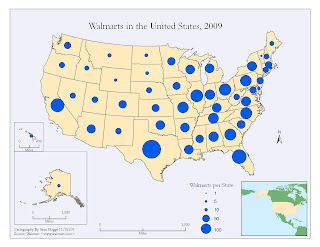
Proportional Symbol Map

A Proportional Symbol map uses symbols of different sizes to represent data associated with the different areas on the map.


Above is an example of a Dot Density map depicting the number of Walmart stores per state in the United States in 2009. The larger the dot the larger the quantity of Walmart stores in that particular state.